
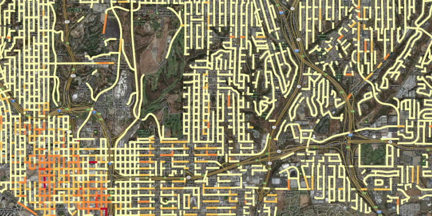
 San Diego Downtown Crime Intensity Heat map, by street segment
The San Diego Regional Data Library ensures civic, social, governments and journalists in San Diego county have usable neighborhood level data they need to run their operations and tell their stories, so they can inform and influence grantors, decision makers and the public.
Visit the Data Library’s main website for details of our work, projects and ideas.
Collections
Latest Datasets
All datasets
- 3-4-50 Deaths 2000-2011
Deaths in San Diego country, for the period from 2000 to 2011, due to the causes - 55+ ADOD and General Population Projections - SD County
Current (2012) ADOD and General population data along with projections for 2020 and 2030 for San Diego county - Annual Survey of School System Finances
Education finance data include revenues, expenditures, debt, and assets (cash - Atlas of Rural and Small-Town America
The Atlas of Rural and Small-Town America provides statistics by broad - CAASPP Test Results
California Assessment of Student Performance and Progress - California Academic Performance Index, 1999 - 2012
API scores for California schools - California Accountability Model & School Dashboard
Datasets for the California school dashboard at - California and San Diego Alcohol Licenses
Records of alcohol licenses in california, from the CA ABC daily file, with - California Healthy Places Index
The HPI provides overall scores and more detailed data on specific policy action - California Law Enforcement Agencies
California's county and agency level context data - California Notary County Codes
Numeric county codes used by California government. - California OpenJustice Datasets
Collection of mulltiple, simpler datasets from OpenJustice that don't require - California Physical Fitness Test Research Data
These research files contain results from the Physical Fitness Test (PFT) - California School District Links to US Census
Links between CDS codes, NCES codes and school district geoids in the US census - California Schools and Districts
California public schools, private schools and districts. - California Unemployment
BLS employment measures for California - Canyon Existing Conditions Maps
Geographic packages for conditions of canyons in San Diego county - Capital Improvement Projects
City of San Diego Capital Improvement Projects - CBA FY15 Online Project Submittals
CBA FY15 Online Project Submittals - Census Cartographic Boundary Files, 2018 vintage
The cartographic boundary files are simplified representations of selected - Child and Adult Care Food Program (CACFP) Sites, 2020
The Child and Adult Care Food Program (CACFP) provides federal funding to - Chronic Absenteeism
Student absenteeism data by ethnicity, gender, program subgroup, and grade span. - Community and City and Tract Boundaries in San Diego County
Combines geographic boundary files for communities, cities and tracts in San - Community and City and Tract Boundaries in San Diego County
Combines geographic boundary files for communities, cities and tracts in San - Community Reinvestment Act Disclosure Files, Table D1-1, 2010 to 2018
Multi-year CRA disclosures for small business originations, per county, year and - Community Reinvestment Act Disclosure Files, Table D1-1,1996 through 2009
Multi-year CRA disclosures for small business originations, per county, year and - County Health Rankings
The CHR&R program provides data, evidence, guidance, and examples to build - County Planning Database
A collection of data for demographics and housing from the Census planning - COVID 19 Statistics San Diego County
Official COVID-19 statistics for San Diego County. - COVID-19 Cases For San Diego County
Cases, deaths, hospitalizations and other data scraped from the San Diego COunty - COVID-19 Data
COVID 19 cases data from Johns Hopkins, augmented and reformtted - COVID19 Data scraped from global sources
A very conprehensive collection of automatically scraped data. - Current Expense of Education
Calculation of current expense (cost) of education per average daily attendance - Current Population Survey, 2023
The Current Population Survey (CPS) is the primary source of labor force - Demographics for California School Districts
Select tables of census data for California school districts, 2020 - Distressed Housing Tracts
An extract of a subset of columns from the FFIEC Census Flat File, including - Distressed Tracts By County
Counts of FFEIC distressed tracts, by county. - Downtown Homelessness Source Package
Source files for San Diego Downtown homeless sleeper counts - Downtown San Diego Homeless Sleepers
Five years of monthly geographic positions for homeless sleepers in Downtown San - Enrollment by school
School-level enrollment by racial/ethnic designation, gender, and grade. - Fashion Valley Stream Discharge Rates
Stream discharge rates for the Fashion Valley station on the San Diego river, - Food Access Research Atlas, San Diego
The Atlas presents spatial data about supermarket accessibility and provides - Gaslamp Homeless Counts
Monthly homeless counts for the Gaslamp district in Downtown San Diego - Gaslamp Homeless Counts
Monthly homeless counts for the Gaslamp district in Downtown San Diego - General Social Survey
General Social Survey collects information and keeps a historical record of the - Geographical Region Names
Country names, and names for US countries, metros, cities and states. - Get It Done Reports
Reports of non-emergency problems submitted by users of Get It Done - HIC Facility Geocoded Addresses
Geocoded addresses for housing facilities in the San Diego CoC. - High and Low La Jolla Ocean Water Levels
High and Low ocean water levels, at the La Jolla station, from year 2000 to - Historic Precipitation For San Diego County
San Diego Hourly Precipitation 2004-2014 - Homelessness Risk Tutorial
Data related to homelessness from an ArcGIS tutorial - Homicides in California
Homicides reported to the California DOJ by local law enforcement. - Hospital Utilization Forecasts
Forecasts for state and national utilization of hospital beads, ICUs and deaths - HUD Housing Inventory Count
Project-level housing inventory for 2012 to 2018. - HUD Point in Time Counts by CoC
Combined years of sheltered and unsheltered homeless counts, by CoC. - International Administrative Boundaries
Geographic boundaries of second-level administrative regions for countries that - LA Homelessness Demographic Survey
Standardized Records from the Demographic Survey of Unsheltered Individuals - LAHSA Homeless Count
Counts of homeless per tract, from the Los Angeles Point In Time Count, for 2018 - Links between LA Tracts and Land Use Codes
<!-- wp:paragraph --> <p><em></em></p> <!-- /wp:paragraph --> <!-- wp:paragraph --> <p><code>sandiegodata.org-la_parcels-2</code></p> <!-- /wp:paragraph --> <!-- wp:paragraph --> <p><a href=" - Local Climate Data For San Diego 2008 to 2018
<!-- wp:paragraph --> <p><em></em></p> <!-- /wp:paragraph --> <!-- wp:paragraph --> <p><code>noaa.gov-localclimate-200808_201807-san-4</code></p> <!-- /wp:paragraph --> <!-- wp:paragraph --> <p>< - Monthly Retail Trade Report
Retail and Food Service sales volume, by months, since 1992 - Multiyear Nightime Light Intensity
Temporally calibrated DMSP-OLS NTL time series data from 1992-2013; and - NLSY97 2013 HDF5 Conversion
The NLSY97 as an HDF5 file - Pedestrian Density By Block and Time
Pedestrian densities, based on data from San Diego's CityIQ system, aggregated - Pedestrians Rhythms By Neigborhood
San Diego's CityIQ system consists of about 4,400 smart street lamps, which use a variety of sensors to track parking, pedestrians, traffic and a variety of environmental conditions. This analysis rev - Post-Secondary Enrollment
Downloadable data about the College-Going Rate (CGR) for California high school - Private Schools in California
Private Schools in California - PSID Active Savings 89 and 94
Measurements of money flows into savings, housing and annuities. - Raw San Diego County Crime Incidents 180 Day Files, 2013-
Unprocessed crime incident files from SANDAG - Raw San Diego County Crime Incidents 2012-2017
Unprocessed crime incident files from SANDAG - Raw San Diego County Crime Incidents, 2007- 2013
Unprocessed crime incident files from SANDAG - Reimbursement Rates
Child Nutrition Program meal program reimbursement rates. - Response to Resistance
Austin Police Department response to police resistance incidents. - San Diego Beachwatch Data
Water quality data for San Diego county beaches. - San Diego Beachwatch Data, With Features
Water quality data for San Diego county beaches from CEDEN, with added features - San Diego Business Clusters
Business in San Diego linked to entertainment clusters and population density. - San Diego City IQ Assets and Locations
All assets types extracted form the San Diego City Iq system - San Diego Coastkeeper Water Monitoring
Monitoring measurements for San Diego creeks. Temperature, pH, conductivity, - San Diego County Alcohol Permits
San Diego County Alcohol Permits - San Diego County Business Sites
Point locations of businesses and tract aggregations of counts of businesses by - San Diego County Coronavirus Cases
- San Diego County Parcel Rasters
Raster maps of Assessor's tax zone, from the azr_zone field of the original - San Diego County Total Maximum Daily Load
TMDL data for San Diego county, through September 2015. - San Diego Crime Incidents with Demographic Descriptions
Crime incidents in San Diego, from 2016 though July 2020 inclusive, with UCR - San Diego Crime Incidents with Victim Descriptions
Crime Victims in San Diego, from 2016 though July 2020, with UCR codes for the - San Diego Demographics By Tract
Age, Race, Sex and Ethnicity, by tract for San Diego county - San Diego Downtown Homless Computer Vision Package
Files and code for analyzing San Diego downtown homelessness data with computer - San Diego Homelessness Contract Annotations
Processed TagTog annotations for homelessness contracts collected by the - San Diego Parking Time Series
15 minute interval parking utilization for 1600 parking zones in San Diego city. - San Diego Pedestrian Counts
Counts of pedestrian traffic from the San Diego CityIQ system - San Diego Planning Database
<!-- wp:paragraph --> <p><em></em></p> <!-- /wp:paragraph --> <!-- wp:paragraph --> <p><code>sandiegodata.org-planning-1</code></p> <!-- /wp:paragraph --> <!-- wp:paragraph --> <p><a href="# - San Diego Point In Time Count 2010, Geo Points
Point data for locations of homeless for the 2010 PiTC count in San Diego - San Diego Point In Time Count 2018, Tracts
Unsheltered counts per tract and sheltered counts per facility, for 2018 San - San Diego Police Calls for Service
San Diego Police Calls for Service, linked to related datasets - San Diego Police Regions and Demographics
Boundary shapes for San Diego neighborhoods, beats and divisions, with ACS 2019 - San Diego Region Crime Incidents 2007 - 2013
Processed crime incidents for San Diego county, 2007-2013. Of our crime - San Diego Roads
Extract from the Sangis Roads_all file, for roads in San Diego city - San Diego Street Lamp Locations
Maps and geo data for the locations of San Diego streetlamps - San Diego Tides, Rain and River Flow
A combined dataset of NOAA weather reports, USGS flow rates for the Sn Diego - San Diego Unified School Enrollment Boundaries
Geographic boundaries for schools in the San Diego Unified school district - SANDAG Average Daily Traffic Volumes 2006-2010
SANDAG Average Daily Traffic Volumes 2006-2010 - SANDAG Traffic Data
A collection of shapefiles use as inputs to the SANDAG traffic model, for a - SANGIS Census Regions
San Diego county Tracts, MSAs and SRAs, based on 2010 Census boundaries, as extracted by SANGIS. - SDHC Meal Programs Data Collection
A collection of files from other data packages, from the California Department - SEZ Lights, Rings and Buffers
Sums of pixel values representing nighttime light intensit, for buffers and - Special economic zones
Information on special economic zones have been individually collected and - Staff Demographic Data
Data files pertaining to staff demographics, credentials and teaching load. - Starbucks Locations
A list of Starbucks locations, scraped from the web in 2017 - State and County COVID-19 Cases
State and country observations from the Covid Tracking Project - Student Discipline
Student discipline and the use of behavioral restraints and seclusion - Student Poverty FRPM Data
Data files pertaining to students eligible for Free or Reduced Price Meals - Survey of Consumer Finances
References to the Survey of Consumer Finances - Survey of Consumer Finances, Inheritance Extract
An Extract from the survey of consumer finances for studying networth and - Survey of Income and Program Participation
SIPP collects data and measures change for many topics including: economic well- - Tracts in San Diego County
<!-- wp:paragraph --> <p><em></em></p> <!-- /wp:paragraph --> <!-- wp:paragraph --> <p><code>census.gov-tracts-2017-sandiego-1</code></p> <!-- /wp:paragraph --> <!-- wp:paragraph --> <p><a href=& - Trolley Ridership
Trolley Ridership for Sept 2013 - Underlying Cause of Death, Assault, 1999 to 2018, By State
Counts and rates for assaults as a cause of death, from a CDC Wonder search. - Unduplicated Pupil Counts
Downloadable files for the Unduplicated Pupil Count (UPC) of free or reduced - US Civic Engagement, Large Cities, 2004 to 2011
Per-capital volunteer hours. The values appear to be the number of hours - US County Boundaries
US county boundaries 500k resolution. - US National Grid, Southern California
UTM Grid Zone 11 - Water Quality Project Example Data
Collection of example data for the Water Project - Zip code (zcta) To County Crosswalk
Maps Cenus zip-code tabulation areas to Counties - ZIP-Tract Crosswalk
Data files linking ZIP codes to 2010 Census tracts.