Introduction to Homeless Data Analysis

In preparation for the Data Science for Non Profits meeting tomorrow night (Wednesday, 9 Oct), I’ve created a Google Colab notebook demonstrating how to access the homeless sleeper dataset and compare the distribution of homeless sleepers to crime, pedestrians and businesses. The main output is this chart ( click to expand).

[ To run this notebook, click on the “Open In Playground Mode”, or make a copy of it to your account. ]

Continue Reading →

Downtown Homeless Data Released

After 8 months of hard work form many volunteers and staff, we’re releasing the first version of the Downtown Homelessness Dataset. This dataset has about 41,900 observations of homeless sleepers on 287 blocks in Downtown San Diego, over 62 months.

The dataset is part of our Homelessness Collection. If you’d like to learn how to work on this dataset and the others in the collection, join us for a working session at the next meetup for Data Science for Non Profits, Wednesday 9 October.

Continue Reading →

Homelessness Data Conversion

The San Diego Data Library is building a detailed data set about Downtown homelessness using 5 years of hand-marked paper maps. The conversion process is human-powered, and we need you help to finish the conversion. When we are finished, we will have a very valuable data for doing detailed analysis of the relationship between unsheltered homeless people and the downtown environment, exploring factors such as restrooms, vacant lots, and the presence of services.

Continue Reading →

Computer Vision For Greater Good!

Use your Computer Vision skills to tackle homelessness.

The Data Library is currently running a data project to convert 5 years of monthly homelessness person locations from scanned paper maps to a geographic dataset. The bulk of the work involves volunteers manually digitizing 350 scanned paper maps in two jobs, but we have enough data to build a computer vision solution.

If you have skills, or motivated interest, in programming OpenCV in Python, you can put your talents to service for humanity, by working on the computer vision portion of this project.

Continue Reading →

Downtown Homelessness Dataset Progress

Over the summer we’ve been working on a project to digitize maps of homeless person counts that have been collected over the last 5 years by the Downtown San Diego Partnership. We now have partial results for three neighborhoods, with data positions shown in the map below.

We expect to have the dataset complete in the next few weeks, and after some additional quality assurance, it will be ready for analysis. If you are researcher, part-time analysts, or concerned citizen who wants to use a unique datasets of 5 years of monthly position reports for homeless individuals, let us know.

Continue Reading →

Exploring San Diego Homelessness

Over the past few months, the Data Library has been involved in several projects to study homelessness in San Diego. The main projects have been:

Last Spring, we got the first portion of the Downtown homelessness data converted with the help of Kearney High students, and this fall, we’ll be finishing the rest of the data conversion and doing data analysis. If you’d like to participate, you can contact me, or watch for our next project meetup.

Continue Reading →

Data for Social Good Workshop: Homelessness and Urban Planning

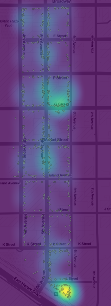
Heatmap of Homeless Count Positions, Gaslamp District, Downtown San Diego.
This is the first in a series of meetings to explore data related to homelessness and urban planning. We will present a broad range of datasets and work together to learn new techniques for data analysis. The data sets we will be using include two collections on the Library data repository:

Once we get familiar with the datasets, we’ll be soliciting data questions from non-profits, journalists and governments, to be added to our Insights Question and Answer service. Then we can use the datasets to answer important regional social questions.

Continue Reading →

Homeless in the Gaslamp District

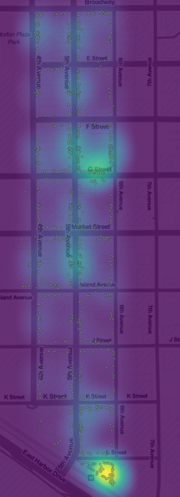
Homeless person count locations and heat map in the Gaslamp district One of the most powerful uses of data is to give people deeper, more specific knowledge about important social issues. Many social problems can be abstract to people who don’t experience them, so making specific links to more common experiences can make the problems more concrete. Grounding the problem of homelessness is why I was so excited to discover that the Downtown San Diego Partnership had more than 5 years of monthly homeless person counts for Downtown San Diego on paper maps. We just needed to digitize the maps to make them useful. With several hundred maps in PDFs, this was going to be a big task. Fortunately, Corri-Anne Burgess, who teaches AP computer science and runs the School of Science, Connections & Technology at Kearney Senior High, was very enthusiastic about involving her students in the project. So, for the last two weeks of the year, her students digitized all of the maps for the Gaslamp district, and then did data analysis projects and presentations. This image is the points and heat map of counts for the data the students digitized. It shows two major clusters of homeless persons in the area. The cluster at C street between 5th and 6th is the south side of the Gaslamp 15 theater, which was closed in February 2016. The Theater is boarded up and has an awning, so it serves as much welcome shelter from the elements. The much more active cluster at 6th and K is a 24 hour public bathroom, one of the few in the Downtown area. Over the Summer, I’ll be working with another student team to build a web application for digitizing the rest of the maps, so hopefully, we’ll have the full dataset in about 6 months. If you’d like to explore this subset, you can download the dataset from the Library’s data repository. 

Continue Reading →